Satellite Radio Weather Forecasts
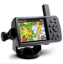
There are new tools available to sailors who want live weather updates without the hassles of Single Sideband radios, GRIB files via email, or Weatherfax transmissions. Both XM and Sirius satellite radio systems now offer subscription-based graphical weather packages that can work with navigational units from Garmin, RayMarine, and various other marine computers. The stated coverage area for both systems is the contiguous 48 United States and its coastal waters, but users have reported coverage as far away as Bermuda and the Caribbean.After receiving queries from many boats about whether or not using the XM or Sirius weather packages was considered outside assistance, this year’s Bacardi Bayview Mackinac Race chairman Lance Smotherman issued an amendment to the sailing instructions stating: “. . . (Boats) may receive weather information from a publicly available web page on the Internet or publicly available subscriptions like XM Weather.”On the Beneteau First 40.7 Bushwacker, we used a Garmin 376C, a handheld, color plotter with antennas for GPS and XM signals. How much information you receive depends upon the subscription level you sign up for, and we had XM’s $50 monthly Master Mariner service, which includes NEXRAD radar, surface wind speed and direction, wave height, marine weather buoy data, satellite mosaic, lightning, severe weather storm tracks, and many other types of data. We found the buoy information most helpful, and it was sure nice to see thunderstorms as they popped up over Michigan and headed our way.


