sea breeze tips
This is a story about the physics of sea breezes. Yeah, I know…the last thing you want is a physics lesson. But take it from me – someone whose grade point average was ruined by Calculus – knowing which way to go in an offshore breeze doesn’t require high math. You just need to understand four different scenarios. And maybe keep a few crib notes in your pocket.
You don’t need to fathom all the scientific principles behind weather mechanics to win a sailboat race. Nor do I have space to describe the effects of local geography on sea and lake breezes, as every sailing venue is different. So to keep things uncomplicated, I’m going to assume a hypothetical, straight coastline, with a racecourse set to the south, offshore. But even if your coastline isn’t straight, read on, for sea breezes behave with predictable similarities everywhere. You might learn that some of the seemingly inexplicable windshifts you’ve experienced over the years aren’t so puzzling after all.
First, to get everyone on the same page, let’s agree on a definition of a sea breeze. Most sailors understand a sea breeze to be an onshore wind, blowing at any time of the day. Scientists would disagree, insisting that a true sea breeze only appears after mid-day, and only after a period of calm or offshore breezes. But heck, scientists always make things way too complicated, so right or wrong, let’s stick with the common understanding. Let’s assume that a sea breeze is simply an onshore wind, and that a lake breeze and a sea breeze are one and the same.
How it behaves depends on many things, but the most important are how hot the land gets, how cold the water is, and what direction the wind is from when you first get out of bed in the morning. The difference between the air temperature over the land and water creates a thermal tug. The greater the difference, the greater the tug. For that tug to be aimed in an onshore direction the land must be warmer than the water. In the simplest terms, as the sun heats the land, the air pressure drops, so air from offshore flows in to fill the void.
The heat of the sun creates this tug (the correct phrase would be a thermal pressure gradient) which can cause a sea breeze to appear from a flat calm. This thermal gradient can also modify an existing wind. Smart sailors know how to play this modification to their advantage. But before we get into that, let’s go back to one of the key things that drives sea breeze behavior – specifically, the direction of the morning wind.
The four types of sea breezes
To come up with a winning strategy in a sea breeze, you first need to decide which of four possible scenarios are present. The scenario depends on the “synoptic gradient,” which I’ve called, for the sake of simplicity, the “morning wind.” This is the “big picture” wind – the wind you would have if there were no thermal effects (no land or sea breeze). If you can feel a breeze when you rig up in the morning, it’s usually the synoptic gradient wind. If that breeze is blowing directly offshore, you should think “pure sea breeze scenario.” If it’s blowing more sideshore, think “corkscrew” or “back door,” depending on which direction the wind is blowing down the coast. When the morning wind is onshore, pull out your cheat sheets for the “synoptic sea breeze” scenario.
Unfortunately, it’s often flat calm in the morning. This is usually the result of a nighttime temperature inversion. This happens when the air hugging the earth cools at night, leaving a layer of cool, calm air underneath a layer of warmer air, “inverting” the normal temperature structure of the atmosphere. There are often a few low clouds just above the inversion, and they will drift with the direction of the synoptic gradient. So if you look skyward from a fixed point, either onshore or at the mooring, you can use clouds to tell the direction and strength of the synoptic wind.If there are no clouds or surface wind, it gets a bit trickier. If you know how to read a weather map, you can estimate the synoptic gradient from sources like the Weather Channel. If you have a computer and an Internet connection, you can check the wind at the offshore light towers. Or you can mathematically calculate the gradient with a shareware program like Digital Atmosphere (available on CompuServe); just follow the software’s instructions to find and download the latest weather observations.
Some scientific assumptions
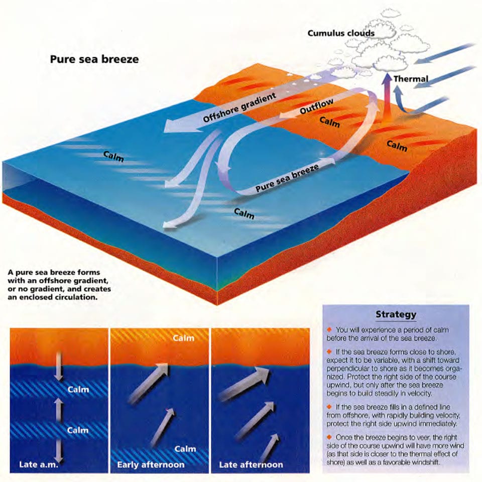
If you browse through a book on meteorology, you’ll likely come across a diagram of “sea breeze circulation.” You’ll see air aloft flowing straight offshore, out over the water, then sinking to the surface and being sucked back inland as a sea breeze. This is the description of a “pure sea breeze,” and while scientifically correct, it fails to describe how the majority of onshore winds behave. Two other sea breeze scenarios – the corkscrew and the backdoor sea breezes – also involve circulation, but instead of flowing in a nice, neat, enclosed loop, the circulation pattern forms a helix as it spirals down the coast. And the final scenario – the synoptic sea breeze – involves no circulation at all.
That meteorology text will also describe, probably in painful detail, a few other complicated principles of weather physics – principles like the Coriolis effect, convergence and divergence. But it’s not important that you understand how they work, as long as you recognize when they are present.
The Coriolis effect causes a “new” wind to veer (shift right). If you suddenly lower the air pressure onshore, as happens when an inversion burns off with the heat of the sun, then air will rush in from offshore. After this initial rush of new wind is established (“established” is a key word we’ll talk about later), the wind will appear to veer. This veer is the Coriolis effect, and suffice it to say that it’s caused by the rotation of the earth on its axis.
An area of “convergence” occurs where the wind piles up, which can result in an increase in velocity in winds blowing nearly parallel to shore. If the shore is on the left when you look upwind, expect convergence along the shore. “Divergence” is the opposite – an area where the wind spreads out and becomes lighter, occurring along a shore that is to your right, facing upwind. So convergence is a factor in the backdoor scenario, as is divergence in the corkscrew scenario.Now let’s look at each scenario individually. I’ll go over the mechanism driving each one, then I’ll offer strategic pointers in the accompanying illustrations (cheat sheets) to help you with your game plan for the race.
Pure sea breeze
This “textbook” sea breeze requires little or no synoptic gradient, or an offshore gradient that is roughly perpendicular to shore – NNW to NNE on our hypothetical shoreline. A pure sea breeze is always preceded by a period of calm; if there is an offshore breeze, it must first die. As this happens, cumulus clouds will often “sprout” over land. Then the onshore sea breeze fills, typically as a line of new wind approaching from offshore.
A pure sea breeze flows onshore, rises with the thermal updrafts over land, then flows offshore and sinks back to the sea, only to return to shore again. This enclosed circulation expands with the day, both offshore and inshore. By sunset it can extend more than 50 miles, from its offshore edges to its inland reaches, in our latitudes. The greater the air-to-water temperature differential, and the weaker the synoptic gradient, the earlier the sea breeze will fill. Hence, an incoming tide that brings cold ocean water close to shore will speed the onset of a sea breeze. Pure sea breezes forming from a NNW gradient are stronger than those forming from a NNE gradient, for the same reason that a corkscrew sea breeze is stronger than a backdoor sea breeze (more on that later).
As long as that offshore synoptic gradient isn’t too strong, a circulating sea breeze can form with as little as a 4-degree air-to-water temperature differential. The smaller the differential, the weaker and later the sea breeze will fill. When the synoptic gradient is strong, it often blows a wedge of hot air offshore as the morning progresses. This wedge forms an “artificial shoreline” which can extend a mile or more offshore (Chicago, for example, in a gradient southwester). The sea breeze will form seaward of this artificial coastline, and then slowly push it toward shore, with a zone of calm in between. Sometimes the two will fight, and the sea breeze might not make landfall until late afternoon.
A pure sea breeze will try to orient itself perpendicular to shore as it fills, or due south in our example. (If the shoreline is irregular, try to take the average axis over a 10- to 20-mile span to determine perpendicular.) Once the sea breeze is “established,” it then builds in velocity. This is when it will begin to veer from the Coriolis effect. The veer is typically 10 degrees per hour in locations in the northern U.S., and 5 degrees in the southern U.S. The shift continues until the wind is angled approximately 45 degrees to shore. At day’s end, a pure sea breeze dies with little further change in direction.
Corkscrew sea breeze
This is the strongest type of sea breeze. It forms when there is a sideshore, or slightly offshore synoptic gradient – between the W and NW on our hypothetical coastline. In this scenario, the wind rarely goes calm before the arrival of the sea breeze. Instead, it slowly backs (shifts left) into a sea breeze, with a period of lighter winds as the breeze makes its initial move onshore. A corkscrew sea breeze circulates, as does a pure sea breeze. But instead of the circulation being roughly enclosed, it spirals down the coast in a helix pattern.
In the morning, the sideshore synoptic gradient creates an area of divergence, or slightly weaker velocity, just off the coast. This makes it easy for a corkscrew sea breeze to form, as air from aloft can sink into the divergent zone and initiate circulation. Hence, this type of sea breeze forms earlier, with less of an air-to-water temperature differential, and can overpower stronger synoptic gradients more easily than other types of sea breezes. It can even form on days when the synoptic gradient wind tops 20 knots, if the temperature differential is 10 degrees or more.
The onset of this sea breeze is signaled by the clearing of haze and low clouds offshore. (This is caused by air sinking into the zone of divergence; when air sinks, it compresses, warms and cloud moisture evaporates.) As the clouds clear, the morning wind will begin backing toward onshore. This backing trend will continue until the pressure gradient stabilizes. This will usually be early afternoon in the late spring, when the water is cold and the land is hot. But in late summer, when the air-to-water temperature differential is smaller, the sea breeze will not be firmly “established” until mid-afternoon.
Once the sea breeze is established, the velocity will build steadily. Only at that point will the breeze begin to veer from the Coriolis effect. From then on the veer will be continual, until the wind has returned to the original synoptic direction, usually by midnight.
Backdoor sea breeze
While the corkscrew sea breeze forms easily – let’s say it comes through the “front door” – when the synoptic gradient is from the opposite direction, a sea breeze has a more difficult time developing. And when it forms, it is more variable than other sea breezes. For lack of a better term, we’ll call this scenario a backdoor sea breeze.
When the synoptic gradient is sideshore or slightly offshore, between NE and E on our hypothetical shoreline, convergence creates an area of stronger velocity just offshore. The convergence also inhibits the sinking of air from aloft and disrupts the formation of sea breeze circulation. Because the sea breeze has trouble forming close to shore, it often forms farther offshore and then tries to fight its way inshore, across the zone of convergence. For a backdoor sea breeze to form, it takes a greater air-to-water temperature differential, and a weaker synoptic gradient, then it does with a pure or corkscrew sea breeze.
In a backdoor scenario, there will be more wind on the left early in the day, as the left is closest to the zone of convergence. Then, in early afternoon and given favorable conditions, a backdoor sea breeze can form offshore, as a SE breeze on our sample shoreline. In between the sea breeze and the convergent wind there is usually a zone of light and shifty air. Slowly, this zone will move toward shore as the sea breeze wins the fight, but it can take much of the afternoon for the sea breeze to make landfall. If the race is started during the fight, boats on both corners of the racecourse will often come out ahead of the those in the middle.
After the sea breeze has moved across the course and inshore, it will begin to veer. This shift will often come in “pulses” of 10 to 15 degrees, rather than a slow, steady, shift to the right. Each pulse is a response to increased heat on shore, the wind taking a “shot” right to relieve the pressure drop on shore. Once the pressure is relieved, the wind steadies out and oscillates as the pressure differential builds again. Then the process is repeated.Given enough time before evening, this sea breeze can eventually veer to nearly perpendicular to shore. However, this type of sea breeze is not as well organized as a pure or corkscrew sea breeze. So it tends to fall apart early in the evening, and as it does, the wind will begin to back toward the synoptic gradient – toward the morning wind.
Synoptic sea breeze
This is the scenario whenever the synoptic gradient is onshore, as is typically the case on the West Coast of the U.S. By definition, an onshore gradient flows day and night, but an inversion sometimes leaves it calm at the surface in the morning. This is the case with the “marine layer” common on the West Coast, where the inversion is marked by low clouds offshore.
On our hypothetical coastline, a synoptic sea breeze would cover gradient winds between the SW and SE. But there are marked differences in how the two extremes of wind will behave. If the synoptic gradient is SW, and you took a look at a weather map of our coastline, you’d notice that there was lower pressure at the upper left, inland. High pressure would be at the lower right, offshore. As the day heats up, the effect is to further lower the pressure on land which intensifies and twists the onshore breeze to the right. But as you sail several miles offshore, away from the thermal effect, the wind will soften and back toward the synoptic gradient. So, as you approach the weather mark, the wind often softens and backs.
Now let’s take a look at the other extreme – a SE synoptic gradient.
Now a weather map would show higher pressure inland, to the upper right. The thermal effect of the afternoon sun would be to erode that higher pressure. The breeze would still veer with the day, but it would also weaken. As you sail offshore, away from the thermal effect, the wind would build and return to its synoptic direction – in this case creating more pressure and a favorable windshift on the upper left side of the course upwind.
Note that in both instances the wind backs as you sail offshore, while near shore the wind veers with the passage of day. The veering trend is not as rapid or pronounced as it is with a circulating sea breeze, because a synoptic sea breeze is not a “new” wind.
Here is how a typical day might unfold with a SW gradient: You get out to the racecourse at mid-to-late morning. Let’s say it’s calm. That means there’s an inversion, which will “burn off” first on shore, then erode seaward. As that happens, the first wind you’ll feel is a touch of the synoptic wind making its way to the surface. Then, as the thermal effects strengthen, the wind will try to square itself toward shore (from the S in our example). This backing trend toward the S will rarely last for more than an hour, and is typically noticeable around midday. By early afternoon, the thermal is causing the breeze to build and slowly veer, with both effects being more pronounced on the right, closer to shore. But if your weather mark is several miles offshore, the last shift is to the left.Now let’s imagine a SE synoptic gradient. A morning inversion is less likely, so you’ll probably sail out to the racecourse in the gradient wind. Now, as the land heats with the rising sun, the wind will simply begin to slowly veer and soften. Again, if the weather mark is several miles offshore, you will see a backing trend at the top of the beat, but this time with more wind.
The strength of a synoptic sea breeze depends on several things. Like all sea breezes, it’s best with a strong air-to-water temperature differential. It’s also enhanced when the inversion is lower and weaker; because then it burns off earlier onshore. In some coastal locations, like San Francisco Bay, a low inversion keeps the sea breeze from spilling over the mountains, instead forcing it into the bays at stronger velocities.
So there you have it. Sounds pretty simple, doesn’t it? Well, now it’s time for a few caveats. The principles described here are only valid in the northern hemisphere. In the southern hemisphere everything is reversed – a mirror image of the north. And we haven’t talked about the effects of friction. A sea breeze forms more easily on low, marshy coast because the air meets few obstacles when flowing onshore. Irregular coastlines can add local effects which can modify our rules of thumb. That said, it is still essential to identify which of the four scenarios is in effect, for only then can you say, “I’ve seen this situation before, so trust me – it pays to go this way.”
The author would like to thank U.S. Olympic Team meteorologist Chris Bedford for his patience in answering hours of questions on this and other topics. Bedford is currently employed at Weather Services Corporation in Lexington, Mass.
**Find more articles from the Sailing World Archives here.
**
